Municipalities and the Subdivision Process
In Saskatchewan, subdivision is guided by The Planning and Development Act, 2007 (the Act), The Subdivision Regulations, 2014, The Statements of Provincial Interest Regulations, and The Dedicated Lands Regulations, 2009. Except for 10 approving authorities*, the Ministry of Government Relations is the subdivision approving authority for every municipality in Saskatchewan.
Under the Act, "subdivision" means a division of land that will result in the creation of a surface parcel or the rearrangement of the boundaries or limits of a surface parcel. Subdivision also includes the removal of a parcel tie that links two or more parcels together to prevent those parcels from being individually dealt with in the land registry if the situation involves:
- A legal subdivision in a quarter section.
- A parcel linked to another parcel if the parcels:
- were deemed to be one parcel of land pursuant to any former Act;
- are separated by a road or railway plan or a water course;
- were held under one certificate of title before the implementation of The Land Titles Act, 2000.
- A parcel that was required to be consolidated with all or part of another parcel by a certificate of approval issued pursuant to the Act or any former Act.
For more information, you may wish to download either the Property Owner's Guide to Subdivision of Land or the Municipalities and the Subdivision Process guide and watch our How to Process a Subdivision Referral webinar. If you have questions, please refer to the Planning Consultant Areas Map, to obtain the contact information of the Community Planning consultant assigned to your area.
Municipalities and developers are encouraged to use the online Land Planning and Development Application to submit proposals for or amendments to a community’s subdivision plans, subdivision bylaws, easements, leases or removal of parcel ties.
Through the review of subdivision applications, the Ministry of Government Relations ensures every new site created is suitable for its intended use. This process takes into consideration public safety, efficient use of infrastructure, and compatibility of adjacent land uses.
* Under section 13 of the Act, the cities of Estevan, Lloydminster, Moose Jaw, North Battleford, Prince Albert, Regina, Saskatoon, Swift Current, Weyburn and Yorkton have been granted subdivision approving authority status.
1. Approval Process
Subdivision approval is required to:
- Obtain a new title to part of an existing parcel.
- Move an existing property line.
- Divide land into lots and roadways.
- Subdivide property by removing a "parcel tie."
- Separate title to a "legal subdivision."
- Secure an interest in part of a parcel for a mortgage, sale or easement.
- Secure an interest for a lease of part of a parcel with a term of 10 or more years.
Subdivision applications submitted to the Government of Saskatchewan by mail or by using the online Land Planning and Development Application must contain:
- A completed Application to Subdivide Land form.
- A plan of proposed subdivision*.
- A current copy of the title to the land.
- Payment covering the appropriate fees.
- Any other document as required.
Applications that do not meet the above requirements will be returned unprocessed. During the review of an application there may be a determination that additional information and/or fees may be required.
A plan of the proposed subdivision must be prepared by a Saskatchewan land surveyor or a registered professional planner.
Fees paid to surveyors and planners will depend on the complexity of the project and the time it takes to prepare and finalize the information. The fees should be agreed upon before the work is started. A list of surveyors and planners can be found in the Related Items below.
* Note: Parcel pictures may be accepted in lieu of a plan of proposed subdivision only where it is proposed to remove a parcel tie from linked parcels which:
- are separated by a road, railway or water course;
- contain no buildings or utility lines;
- have suitable topography; and
- where no road widening is required.
Confirmation of a parcel tie, titles and parcel pictures can be obtained from Information Services Corporation (ISC).
An Application to Subdivide Land form must be completed and signed by the registered landowner or a person authorized by the landowner. An authorized person may be a future owner who has a written agreement with the landowner, or a lawyer, surveyor, planner or other agent hired by the landowner or authorized person. All agreements should be conditional on approval being granted.
A plan of proposed subdivision must show the existing and proposed:
- Subdivision or property lines with dimensions and lot, block or parcel designations.
- Buildings, structures, utility lines and other development on or near the land.
- Well and sewer sites including distances to boundaries.
- Roads, streets, lanes, driveways, trails and highway approaches.
- Topographical details and natural features such as lakes, rivers, creeks, hills, slopes and trees.
Proposed subdivision plans and applications to subdivide land can be submitted to the ministry by mail or by using the online Land Planning and Development Application.
2. Review Process
Each application is different and more complex applications take longer to process.
The applicants will receive a letter from the Government of Saskatchewan acknowledging receipt of their application(s). The letter will explain applicable standards and options, advise if more information is required and identify who has been sent a copy of the application for comments.
Applications are referred to the local municipal council, utility companies and other government offices that may contact the applicant(s) for more details. Letters and permits received by the applicant from these offices should be submitted with a subdivision application.
Applications are reviewed to ensure they conform with provincial and municipal planning standards.
Standards include:
- planning and zoning bylaw land-use controls;
- flood protection and slope stability;
- minimum and maximum site dimensions;
- utility and servicing agreements;
- health requirements such as plumbing systems;
- compatibility with surrounding land uses;
- the availability of a suitable water supply and sewage disposal method;
- legal and physical access to a public road;
- traffic safety and highway access;
- protection of heritage resources and rare species; and/or
- provision of public lands such as roads and parks.
If an application is in complete and final form, legislation allows a subdivision approving authority 90 days to make a decision. After the 90-day period, the applicant(s) may be asked to grant more review time or file an appeal to have a decision rendered. On average, the time from the date received to the date approved is 150 days and the current turnaround time for applications deemed to be in complete and final form is 30 days.
No binding contracts for the land should be made and no construction or site preparation work should be started until the Ministry of Government Relations completes the application review and issues a decision.
3. Additional Requirements
Municipal Requirements
Applicants should consult a municipality about its requirements. A subdivision proposal must conform to all provisions in any district plan, official community plan and zoning bylaw. These bylaws may limit permitted land uses, specify minimum lot or parcel sizes, and regulate building locations.
A municipality may require the subdivision applicant to enter into a servicing agreement covering the construction of new roads or other services necessitated by the subdivision.
Municipalities are encouraged to require people applying for either a subdivision approval or a development permit to build or pay for the new roads required to service the development. You can find more details and sample agreements on our Servicing Agreements page.
Subdivision applicants must provide municipal reserve land for public use. Exceptions exist for the first parcel in a quarter section, agricultural parcels larger than four hectares or property line relocations.
Subdivisions for residential purposes must provide 10 per cent of the gross area as municipal reserve; other subdivisions must provide five per cent. Applicants may be able to defer the requirement or in lieu of dedication, make a monetary settlement with the municipality. Any flood-prone or unstable land may also be required to be dedicated as environmental reserve. You can find more information on our Municipal Dedicated Lands page.
Rezoning
Rezoning procedures are found in The Planning and Development Act, 2007 (PDA). The PDA requires a municipality to advertise its intention to rezone land once a week for two successive weeks in a local newspaper after which the municipality must hold a public hearing at least one week after the second newspaper ad is published. In some cases, the municipality must also obtain ministerial approval. You can contact the municipality for more details.
Utility Requirements
A utility easement agreement is a contract in which a landowner grants a municipality or a utility company the right to install lines or ditches on part of the landowner's property. The granted part is usually called a "right-of-way." A utility easement agreement can be registered on the title to land as a permanent interest.
Utility companies are asked to comment on extending and protecting service lines. Line locations must be shown on a plan of proposed subdivision. Utility companies may ask subdivision applicants to enter into easement, installation or relocation agreements.
Note: People planning new construction or excavations must contact all utility companies for line locations and service connections.
Assistance is available by calling Sask1stCall at 1-866-828-4888 or visiting the Sask1stCall website.
Water Supply and Waste Disposal
Residential development must be served by acceptable water, sewer and garbage systems. Multiple lots should be connected to communal systems.
In the case of a rural or isolated site, health regulations require a residence using a sewage lagoon, seepage pit or jet disposal to have a minimum parcel size of four hectares. A lagoon must be 30 metres from property lines, a pit three metres and a jet 60 metres. Otherwise, a mound or buried absorption system must be installed or sewage must be hauled to an approved disposal site.
Highway Requirements
Ministry of Highways permits are required to build highway approaches or other development within 90 metres of a highway. Land may be required for highway widening or service roads. Landowners are responsible for road and/or driveway construction.
4. Fees
Section 9 of The Subdivision Regulations, 2014 outlines the fees associated with the examination of subdivision applications. These fees represent a portion of the cost to the ministry to review and render a decision for subdivision applications. The fees are as follows:
- $300 for each new parcel created by the subdivision
- This amount is non-refundable.
- Parcels for public highway, dedicated lands or public works are exempt from this fee.
- If more parcels are added to the plan of proposed subdivision during the review of a subdivision application, an additional per parcel fee is required.
- Refunds will not be provided for a reduction in parcels.
- $150 per application for a Notice of Decision
- In the event an application is withdrawn before a decision is made, this amount will be refunded.
- $100 for the re-issuance of a Notice of Decision, if necessary
- Pursuant to section 129 of the Act, a Notice of Decision is valid for 24 months and may be extended once for an additional 24 months if the request is received before the expiry date.
- If the deadline has passed, the request will be deemed a new application that is subject to the full fees.
The fees are exempt from GST and PST and can be paid online through the Land Planning and Development Application for online subdivision applications or by check or money order made payable to the Saskatchewan Minister of Finance for paper submissions.
Additional fees may be applicable for registering any interests (i.e. caveats) respecting a subdivision application. A caveat is a legal instrument applied to land through Information Services Corporation (see Interest Registration Services > Registration of all Other Interests). A caveat informs people looking at the title of additional interests held in the land by parties other than the landowner. The Act allows subdivision approving authorities and municipal councils to register caveats. During the review of a subdivision application, the Ministry of Government Relations will advise applicants if there are additional fees associated with their application.
Sample Urban Scenarios
Disclaimer: The bold dashed line in these scenarios is shown for illustrative purposes only. Final determination of application fees is subject to review.
In an urban context, the bold dashed line must outline all the parcels being created or modified as a result of subdivision, and all parcels are subject to the $300 per parcel fee.
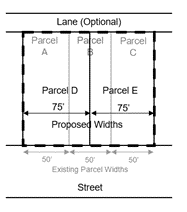
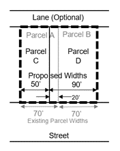
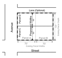
Each of the following four examples are subject to a fee of $750, based on $600 for two parcels plus $150 for issuing a Notice of Decision.
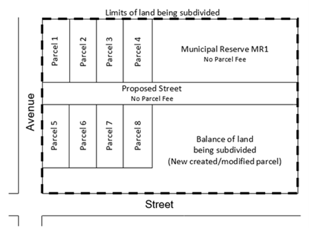
The example below is subject to a fee of $2,850, based on $2,700 for nine new parcels plus $150 for issuing a Notice of Decision.
Sample Rural Scenarios
Disclaimer: The bold dashed line in these scenarios is shown for illustrative purposes only. Final determination of application fees is subject to review.
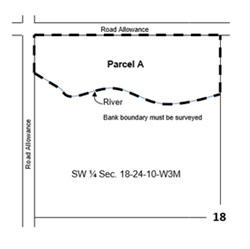
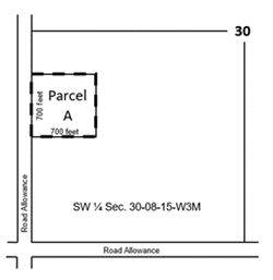
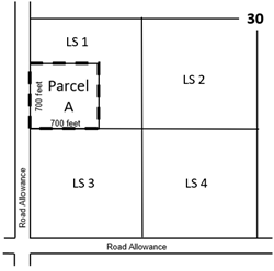
The following examples are subject to a fee of $450, based on $300 for one new parcel plus $150 for issuing the Notice of Decision.
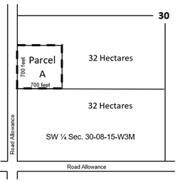
The example below is subject to a fee of $750, based on $600 for two new parcels plus $150 for issuing a Notice of Decision.
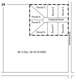
The example below is subject to a fee of $2,550, based on $2,400 for eight new parcels plus $150 for issuing a Notice of Decision.
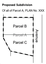
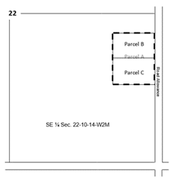
The following subdivision is subject to a fee of $450, based on $300 for new Parcel B, $150 for issuing a Notice of Decision.
Parcel Tie Scenarios
Disclaimer: The bold dashed line in these scenarios is shown for illustrative purposes only. Final determination of application fees is subject to the Ministry of Government Relations' review.
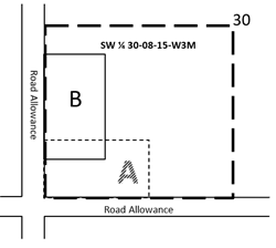
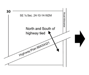
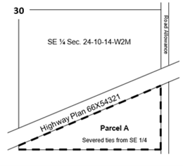
The example below is subject to a fee of $450, based on $300 for the subdivision of a single parcel tie removal, plus $150 for issuing a Notice of Decision.
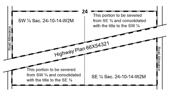
The example below is subject to a fee of $750, based on $600 for the parcel tie re-arrangement that results in two new parcels plus $150 for issuing a Notice of Decision.
5. Notice of Decision
Once a review is complete a written decision is issued. Approved applications are issued a Certificate of Approval that must be sent with a plan of survey and other documents to Information Services Corporation in order to register the subdivision.
Registration involves two separate steps: registering a new survey plan and applying for titles to the land shown on the survey plan. Please contact Information Services Corporation for Land Registry processing times.
You can contact us for more information on options for applications approved with conditions, approved in part or refused.
Certain Notices of Decision may be appealed. You have 30 days in which to file a written notice of appeal along with a $50 filing fee with the Planning Appeals Committee of the Saskatchewan Municipal Board.
If the Committee allows your appeal to proceed, you or your representative must attend a hearing at which the subdivision application and requirements are discussed. After all interested parties are heard the Committee will render a decision granting or denying the appeal.
If the appeal is granted, the approving authority is instructed to issue an approval.
If denied, the applicant cannot submit the same application again for at least six months; however, revised applications may be considered. The Committee may also impose conditions that an applicant must meet. For more details see our Appeals page.